|
|
|
|
|
|
 |
MARY E. POWER, Professor,
Integrative Biology University of California, Berkeley
Berkeley, CA 94720-3140 mepower@berkeley.edu |
|
Personal history I have been fascinated since childhood by snorkeling in clear water, and watching at close range as fish, amphibians, reptiles, and charismatic invertebrates wend their ways through landscapes of algae, macrophytes, and rocks. Why do they do what they do, and how do they get enough to eat? And avoid being eaten? Over the years, this interest has been channeled towards addressing three questions: how do organisms respond to variation in the availability of their food, what factors constrain their responses, and how do their responses (or lack thereof) affect the ecosystems that they live in? |
 |
 |
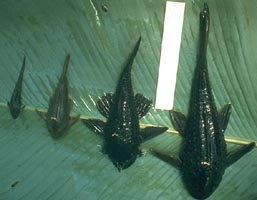
I got to immerse
myself in these questions, and a tropical stream in central Panama, during
3 years of field work on the grazing ecology of a bizarre and fascinating
family of armored catfish (Loricariidae).
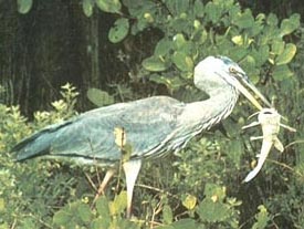
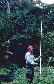
My husband Bill Dietrich, at the time, a U. Washington Geology grad student, helped me map 3 km of the Rio Frijoles in Central Panama in great detail. This mapped proved invaluable in understanding spatial and temporal factors driving variation in catfish density and habitat use. I followed 1308 marked individuals (some became close friends) around the Rio Frijoles for three years. Gradually, their responses to variation in their food over various spatial scales became apparent. On a pool-to-pool scale (100-1000 m scale), they responded to light-driven variation in algal growth rates and the density of their conspecifics, coming very close to Fretwell's Ideal Free Distribution . Within a given pool (over cm-m scale depth gradients), armored catfish distributed themselves vertically to avoid the danger of fishing birds and mammals in shallow water. |
|
|
Even in the dry season when they were most food limited, larger loricariids strictly avoided water < 20 cm deep, where the time interval between splash and spearing of bird beaks was too short for escape. On the smallest spatial scale, their return times to previously grazed sites on substrates were determined by renewal rates of algae at the site, stresses imposed by sediment that settled on substrates between grazing bouts , and competitive pressure from other grazing loricariids. |
|
|
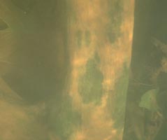 |
When catfish were stocked at 1/5 to 1/10 their natural densities, loricariids enhanced both the per area productivity of their food and even standing crops by removing sediment from epilithic diatom films. | 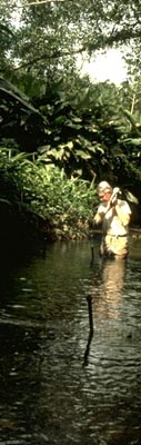 |
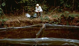
| My 72 year old father, Wilson Power, hiked three miles up the Rio Frijoles in central Panama to help me install the enclosures we built, with fencing, solid iron pipes and a shackle, instead of a sledge hammer, all salvaged from the Panama Canal Co. Dredging Division. | ||
 |
My mother, Eleanor Power, holds the Guiness record for the longest period of continuous observation of an armored catfish in the wild (8 hours). | |
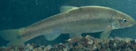 |
After we fledged from University of Washington, Bill got a job at Berkeley and I got a chance to work with Bill Matthews and Art Stewart at the University of Oklahoma on the ecology of another algae-grazing fish, Campostoma anomalum. |
| Bill had recognized that this minnow, abundant throughout streams of the Midwestern US, was probably exerting important ecosystem effects, and invited me to the University of Oklahoma Biological Station to check them out. As thin soft fish, Campostoma remain vulnerable throughout their lives to piscivorous large-mouth and spotted bass. | 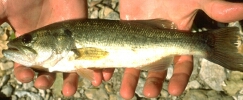 |
| Therefore, pools with bass in prairie streams lacked minnows and filled with green attached algae, while pools that lacked bass were grazed to a barren state by minnows . This three-level 'trophic cascade' parallels that discovered by Jim Estes and colleagues for sea otters, sea urchins and kelp . In larger Ozark rivers of northeastern Oklahoma, however, large schools of Campostoma range from pool to pool, unimpeded by abundant small mouthed bass. |
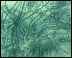 |
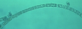
We don't yet know why bass fail to suppress Campostoma in these larger rivers. Possibly, the minnows can avoid predators in the larger more complex pools. Also, these small-mouthed bass prefer crayfish to fish as prey. Crayfish abound in the rivers we studied, possibly because bass were suppressed by anglers or larger predatory fish (e.g., these Ozark streams may have 4 level functional food chains). In any case, Campostoma had interesting effects on the algae, maintaining adnate mats of nitrogen fixing cyanobacteria, which in the absence of grazing were rapidly overgrown by filamentous diatom colonies, which minnows preferred to their normal, cyanobacterial bill of fare . |
|
There are ecosystem level implications, for the clarity and productivity of Ozark rivers, which have yet to be tested on larger scales.
|
 |
|
Recent and ongoing work In 1987, I was fortunate to get a job at Berkeley, where Bill Dietrich teaches geomorphology. Since that time, I have focused on food webs in and around northern California rivers. |
|
 |
My students, colleagues and I have worked since 1988 at the Angelo Coast Range Reserve in Mendocino County, doing observational and experimental studies of how food webs respond to web members, hydrologic and productivity regimes , and spatial heterogeneity, from substrate texture to landscape position . We tend to focus on two response variables: how do food web interactions and environmental conditions influence the amount of green biomass (filamentous algae and epiphytes) that accrues in rivers ? How do environmental conditions and food web interactions influence the amount of insect emergence from rivers, fluxes of insects into surrounding watersheds, and the interactions of terrestrial insectivores with these prey? A question of increasing interest centers on the spatial scales of food webs, and the interplay between spatial energy sources to food webs and local interactions within them (Finlay et al. 1999, 2002, Power and Rainey 2000). |
|
New directions and collaborations (see research section) I was fortunate to work over the last ten years with earth and atmospheric scientists, environmental engineers, modelers, and biogeochemists in the NSF-sponsored Science and Technology Center, the National Center for Earth Surface Dynamics (NCED). NCED chose the Angelo Reserve as its first collaborative field site. Through NCED support and other support from NSF, the Goldman Fund and the Keck Foundation (Prof. Inez Fung’s Hydrowatch program), we have at the Angelo Reserve modern laboratory facilities, high resolution Lidar-based digital elevation maps, and a wireless environmental sensor network. These mapping, sensing, and tracing technologies can, with intense on the ground field work, reveal hydrologic, geomorphic, and ecological conditions and trends over expansive scales with unprecedented resolution. Much of my future research will be collaborative, with earth, ocean, and atmospheric scientists, to try to understand the key feedbacks between local population dynamics and species interactions, and larger scale environmental forcings and feedbacks. Understanding why hydrologic and ecological regimes change across space and time leads to hypotheses about how they might change in the future with altered land use, biota, or climate. This hypothesis-driven (‘predictive mapping’) links from organismal (biophysical, physiological) to drainage-network, watershed, or regional scales. Predictive mapping is an iterative approach, using process-based insight from field work and monitoring to generate testable predictions about controls in watershed ecosystems. These predictions are tested (validated) by ground-based experiments and observations in new locations, as well as larger scale remote sensing observations. Harnessing digital mapping and sensing data to probe the scope, domains and mechanisms of these controls and key interactions, we should be able to use predictive mapping, newly informed by advanced technology, to forecast futures and potential resiliency of any watershed. |